Bound Images
The Attribution, Placement, and Meaning, of a Map of New England
by Matthew Edney
The maps of New England (Fig. 1) within the Boston and London editions (both 1677) of William Hubbard’s history of King Philip’s War in southern New England (1675–76) call into question common misunderstandings of the nature of maps that have significant implications for understanding the interrelationships of maps and books. Those misunderstandings are (1) that maps are “pictures” that give their readers direct access to the world and (2) that maps are material, self-contained things whose meanings are fixed and independent of any parent books. Together, these misunderstandings make maps-in-books appear quite distinct from their parent books, when this is manifestly not the case.
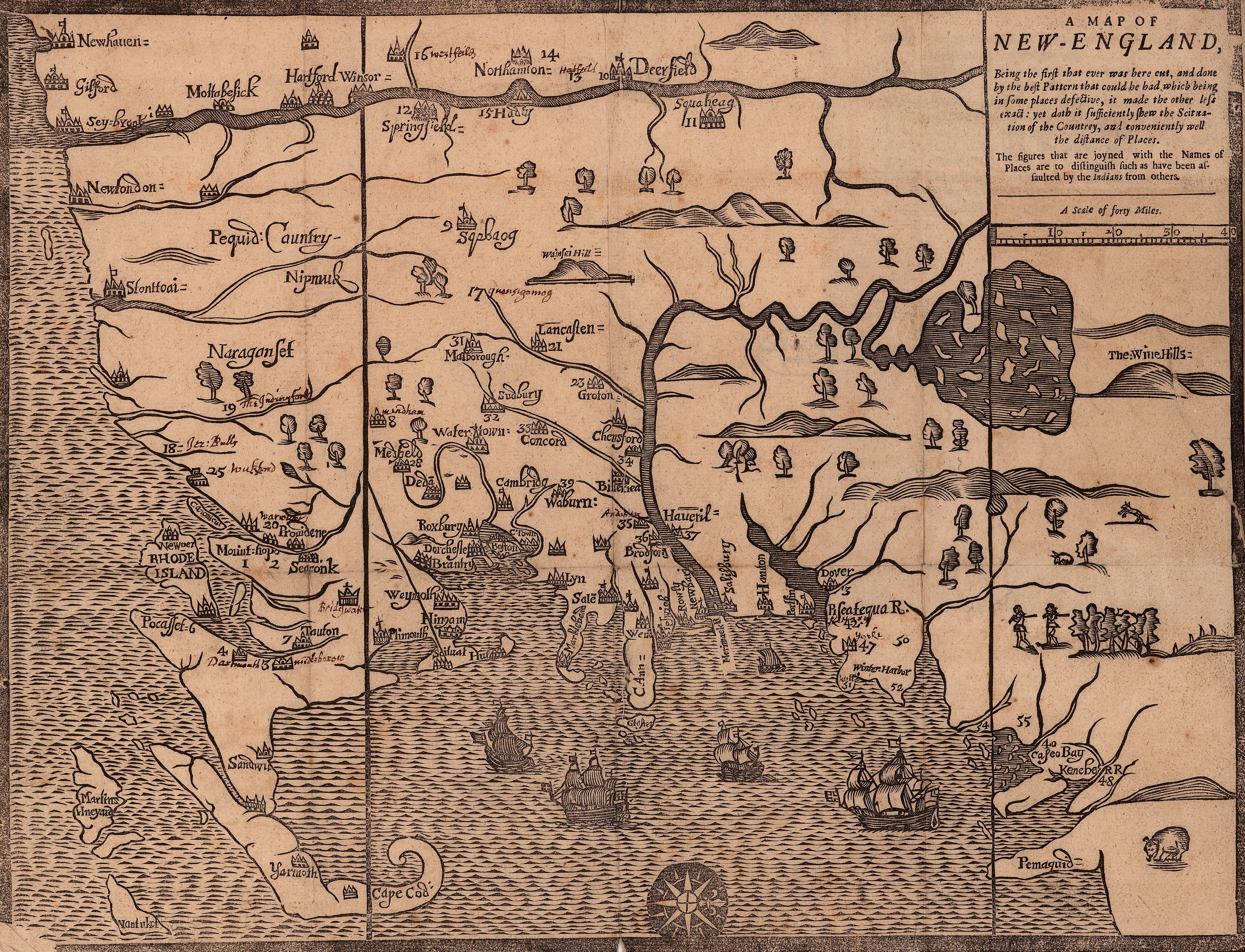
Both maps of New England have been routinely credited since the mid-nineteenth century to the Boston printer John Foster. This attribution gives credit to the man who physically created the map as a material artifact: Foster printed the first map and edition of the book, and is presumed to have cut the woodblock for the map’s matrix. The long-standing practice of crediting authority for maps to their engravers and publishers is justified by the fact that theirs are often the only names to appear on early maps. Even so, engravers and publishers are frequently still credited even when authority for the design of the map image is actually known (Lane 1986). Yet no-one ever refers to either edition of the history of King Philip’s War as being Foster’s. This differential points to the apparently disparate essences of maps and books. Maps are material, books are intellectual. Maps are things, books are words. The algorithmic reading of maps as “pictorial” devices (see Edney 2019, 58–64) gives direct access to the world, whereas books give access to the words and thoughts of the authors. If authors are crucial to their books, authors of maps are irrelevant and have been actively ghosted by historians.
That Hubbard was the author of the map in his book, and should be credited as such, is clear from a detailed study of the first edition of Hubbard’s book (Edney and Cimburek 2004). The map contains lots of numbers in lieu of place names and in the Boston edition the map was bound into the middle of the volume to introduce an unnumbered, seven-page section, with the heading:
A Table shewing the Towns and places which are inhabited by the English in New-England: those that are marked with figures, as well as expressed by their names, are such as were assaulted by the Indians, during the late awfull revolutions of providence.
Each paragraph in this table began with a number and the name of a place and then briefly listed the events that had occurred at that location, mostly Indian attacks on English settlements; most paragraphs provided further cross-references to pages elsewhere in the volume where more in-depth accounts of the events could be found (Fig. 2). The paragraph numbers referenced places on the map that preceded the table; many of the towns indicated on the map bore only a number. This wealth of empirical data and its distribution on this map were essential to Hubbard’s overall demonstration, contra Increase Mather, that the war had not ended because Mather had reestablished the Puritans’ salvific Covenant with God, but because God had miraculously interceded for the English at a few key moments. In this context, wrapped up within and integral to the book, the map serves as an analytical device more than it does a locational one.
[Figure 2]
However, when printers in London got ahold of an impression of Hubbard’s book and reprinted it, they copied the map but they bound it at a different location within the book: directly after the prefatory material and opposite the first page of the main narrative. Such placement was common for imperially minded English books about distant places. Removed from the ostensible context of the table, and being read by readers in old England who had little access to other detailed maps of New England, the Wine Hills map in situ emphasized the geographical stage on which the historical action took place, downplaying its analytical function and religious significance.
That is, in the Boston book, the map began an indexical chain leading from the map to the table to the text: where does the map text end, and the verbal text start? This map is not a self-contained thing; its meaning is not dependent solely on the manner in which it depicts the world; it is not semiotically closed. Rather it is completely integrated into the larger whole, a demonstration of intertextuality. In the London book, the map might have lost that overt indexicality, but it too would have been read as part of the book. More generally, regional maps are always fully integrated into arrays of other written and graphic texts. Regional maps are not read in isolation. Hubbard only made explicit what is implicit in other geographical writing, that readers are expected to move from map to narrative and back again, so that maps blur semiotically with the written word. The same principles apply to all kinds of maps: they are all semiotically open. This means that the map image is not constrained by the physical edge of the paper that demarcate the map object. Where do maps end?
Even as I argue that authority for the map in the Boston edition of Hubbard’s history should be credited to Hubbard, the back of my brain is yelling about the “death of the author.” In the case of the Boston edition, Hubbard was at home in Ipswich when the map and book were printed, and Foster certainly intervened in the setting of the text. My insistence on Hubbard as the author of the map is primarily rhetorical, to rescue him from perpetual ghosting. On the other hand, the placement of the map in the London edition fundamentally changed the meaning of the whole work. Removed from Hubbard’s theological argument, the Wine Hills map—and book—can no longer be said to be his.
__________
Edney, Matthew H. 2019. Cartography: The Ideal and Its History. Chicago: University of Chicago Press.
Edney, Matthew H., and Susan Cimburek. 2004. “Telling the Traumatic Truth: William Hubbard’s Narrative of King Philip’s War and his ‘Map of New-England’.” William & Mary Quarterly 3s 61, no. 2: 317–48.
Hubbard, William. 1677. A Narrative of the Troubles with the Indians in New-England…. Boston: printed by John Foster.
———. 1677. The Present State of New-England. Being a Narrative of the Troubles with the Indians in New-England…. London: Thomas Parkhurst.
Lane, Christopher W. 1986. “Whose Map Is It Anyway?” Map Collector 36: 16–20.